測繪儀器/三腳架/經緯儀三腳架/經緯儀木三腳架
測繪儀器三腳架:穩固支撐,助力精準測量
在測繪工作中,三腳架是不可或缺的重要輔助工具。它為各類測繪儀器提供了穩固的支撐平臺,確保測量數據的精準可靠。經緯儀木三腳架作為其中一種經典款式,具有獨特的魅力和實用價值。
產品介紹
一、材質與結構
經緯儀木三腳架采用優質木材制作,木材經過精心挑選,具有良好的韌性和強度。木材的天然紋理不僅賦予三腳架美觀的外觀,還使其在不同環境條件下都能保持穩定的性能。三腳架的結構設計合理,三條支腿均勻分布,形成穩定的三角支撐結構,能夠有效分散儀器的重量,確保儀器在測量過程中的穩定性。支腿之間通過堅固的連接部件相連,既保證了整體的牢固性,又便于拆卸和組裝,方便用戶在不同場地進行快速安裝和收納。
二、適用范圍
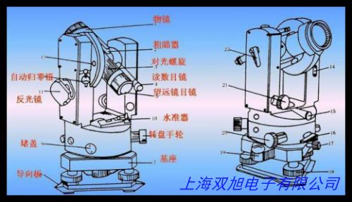
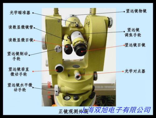
該三腳架專為經緯儀設計,能夠完美適配多種型號的經緯儀。經緯儀是一種用于測量角度的高精度儀器,廣泛應用于建筑工程、土地測繪、道路施工、礦山勘探等領域。在這些領域中,經緯儀木三腳架為經緯儀提供了穩定的支撐,確保測量角度的準確性,從而為工程項目的規劃、設計和施工提供可靠的數據支持。無論是平坦的地面還是有一定坡度的地形,經緯儀木三腳架都能憑借其獨特的結構和材質優勢,適應不同的測量環境,滿足用戶多樣化的測量需求。
三、使用與維護
使用經緯儀木三腳架時,用戶只需將三條支腿展開并調整到合適的長度,使三腳架平穩地放置在測量點上。然后將經緯儀安裝在三腳架的頂部,通過調節支腿的伸縮和角度,使儀器達到最佳的測量位置。在測量過程中,三腳架能夠有效抵御外界因素的干擾,如微風、地面震動等,保證測量數據的穩定性和一致性。為了延長三腳架的使用壽命,用戶在使用后應對其進行適當的維護。例如,清理支腿上的灰塵和雜物,檢查連接部件是否松動,定期對木材表面進行保養,防止木材因長時間暴露在空氣中而出現干裂或變形等情況。通過合理的使用和維護,經緯儀木三腳架能夠長期保持良好的性能,為測繪工作提供持續可靠的支撐。
經緯儀木三腳架以其獨特的木質結構、穩定的支撐性能和廣泛的適用范圍,成為了測繪工作中理想的輔助工具。它不僅能夠滿足專業測繪人員對測量精度的要求,也為相關領域的工程技術人員提供了便捷、可靠的測量解決方案,助力各類工程項目順利開展,為工程建設和地理信息獲取提供堅實的基礎支持。
Mapping Instrument Tripod: Stable Support for Accurate Measurement
In the field of mapping, a tripod is an essential auxiliary tool. It provides a stable support platform for various mapping instruments, ensuring the accuracy and reliability of measurement data. The wooden tripod for theodolite, as a classic style, has its unique charm and practical value.
Product Introduction
I. Material and Structure
The wooden tripod for theodolite is made of high-quality wood. The wood is carefully selected for its good toughness and strength. The natural grain of the wood not only gives the tripod an aesthetically pleasing appearance but also ensures its stable performance under different environmental conditions. The tripod has a well-designed structure with three evenly distributed legs, forming a stable triangular support structure. This structure can effectively distribute the weight of the instrument, ensuring the stability of the instrument during the measurement process. The legs are connected by sturdy connecting parts, which not only ensure the overall firmness but also facilitate disassembly and assembly, making it convenient for users to quickly install and store it in different places.
II. Application Range
This tripod is specially designed for theodolites and can perfectly match various models of theodolites. Theodolite is a high-precision instrument used for measuring angles and is widely used in fields such as construction engineering, land surveying, road construction, and mine exploration. In these fields, the wooden tripod for theodolite provides stable support for the theodolite, ensuring the accuracy of the measured angles. Thus, it provides reliable data support for the planning, design, and construction of engineering projects. Whether on flat ground or on sloping terrain, the wooden tripod for theodolite can adapt to different measurement environments with its unique structural and material advantages, meeting the diverse measurement needs of users.
III. Use and Maintenance
When using the wooden tripod for theodolite, users simply need to unfold the three legs and adjust them to the appropriate length, placing the tripod stably on the measurement point. Then, the theodolite is installed on top of the tripod. By adjusting the extension and angle of the legs, the instrument can be positioned at the best measurement location. During the measurement process, the tripod can effectively resist interference from external factors, such as light wind and ground vibrations, ensuring the stability and consistency of the measurement data. To extend the service life of the tripod, users should perform appropriate maintenance after use. For example, clean the dust and debris from the legs, check whether the connecting parts are loose, and regularly maintain the surface of the wood to prevent it from cracking or deforming due to long-term exposure to air. With proper use and maintenance, the wooden tripod for theodolite can maintain good performance for a long time, providing continuous and reliable support for mapping work.
The wooden tripod for theodolite, with its unique wooden structure, stable support performance, and wide application range, has become an ideal auxiliary tool for mapping work. It not only meets the requirements of professional mapping personnel for measurement accuracy but also provides a convenient and reliable measurement solution for engineering technicians in related fields. It helps various engineering projects to be carried out smoothly and provides a solid foundation for engineering construction and geographic information acquisition.
測繪儀器/三腳架/經緯儀三腳架/經緯儀木三腳架
高檔 高精度水平儀水泡 360度全磨精度,水準儀器水準泡經緯儀 質量保證售后無憂,金屬圓水準器超小金屬萬象水準器水平儀攝影器材專用水準泡,蘇州一光LT402L上下激光電子經緯儀DT402L激光對點,新款上市蘇一光DT402L電子經緯儀帶激光下垂點替代DT302L。 高精度電子激光經緯儀全站儀,RIKEN 理研 攜帶用精密水準器,SIGMA KOKI西格瑪光機平面基板OFPXP-80100R15-10,CX7DVD導航 馬自達專車專用GPS導航 導航一體機,全新料制 塑料管狀水準泡 重質量生產。昌匯 全套各線數經緯密度鏡緯密鏡面料密度鏡 64,41,80,120,水平儀,永高電力DT-2電子經緯儀DT-2經緯儀, 經緯儀 全站儀 垂準儀 鋁合金三腳架 實。祥瑞德 搖表ZC兆歐表250v500V1000V2500V 精致鋁殼絕緣電阻測試儀,Garmin佳明 etrex 209X GPS手持行業版測量測繪采集經緯度 測面積,國產低價位經緯儀 DT-2,馳度觀測儀 智能型裂縫寬度觀測儀 觀測經緯儀 ,全站儀中緯ZT15/ZT15R 工程測繪棱鏡水準儀經緯儀激光測量。
上一篇 集思寶G138BD定位戶外GPS手持定點定位經緯度測量 http://www.uoncy.cn/product/d122584.html
|